
North Carolina ZIP Code Coverage
North Carolina has a large, changing set of five-digit ZIP Codes and ZIP+4 delivery routes. The statewide view below uses ZIP3 prefix bands only to orient a search by region. It does not list every active ZIP, name every post office, or draw exact delivery boundaries. The USPS assigns delivery geography by address, and its lookup is the right way to verify one complete address. A county GIS or parcel site can then show where that address sits on the ground.
| ZIP Code | Areas Covered | Post Office | Notes |
|---|---|---|---|
| 270-274 prefix range | Northwestern Piedmont, including Winston-Salem, Greensboro, and nearby communities | USPS delivery offices and postal city labels vary by five-digit ZIP | Regional orientation only; verify each address |
| 275-279 prefix range | Triangle, Sandhills, central and eastern areas, including rural and coastal routes | Raleigh, Durham, Chapel Hill, Goldsboro, Outer Banks, and many local routes | May cross city and county lines; some are PO box or unique-use |
| 280-284 prefix range | Charlotte metro, south-central Piedmont, Fayetteville, and southeastern interior | Local post office names may differ from the incorporated municipality | County parcel filters vary by portal |
| 285-289 prefix range | Eastern and coastal areas, southeastern communities, and western mountain towns | New Bern, Greenville, Wilmington, Asheville, Boone, Hickory, and surrounding routes | ZIP3 is not a five-digit search value |
| Five-digit ZIP | Address-specific post office, route, or delivery area | Assigned by USPS for the full delivery address | Check in USPS and note the date |
| ZIP+4 | Address or unit-level delivery segment | Depends on exact address and delivery routing | Not a resident directory |
| PO-box-only ZIP | Post-office box service | Associated post office, not necessarily a residential situs | Use a physical address or parcel PIN for land records |
| Unique or institution ZIP | A large institution or campus | May be a nonresidential delivery destination | Verify the specific address in USPS |
A postal city can be a nearby place name rather than the municipality around the building. One city may use several ZIPs, while one ZIP may cross a city or county line. A PO-box-only or institution ZIP may have no ordinary residential parcel base. For those cases, keep the post office result as a mailing fact and use the physical site address or PIN for county records.
Verify North Carolina ZIP Codes
For a specific delivery point, begin with the USPS ZIP Code Lookup by address. Enter the complete street address, including unit details when relevant, and retain the result as a postal check. The returned ZIP belongs to the delivery address as USPS recognizes it; it does not establish the city limit, county line, parcel owner, or the identity of residents. Record the day you checked it because routes and postal labels can change.
The USPS address-to-ZIP screen shows the official method for checking one mailing address. It is a useful first check before comparing the postal label with county map and tax records.
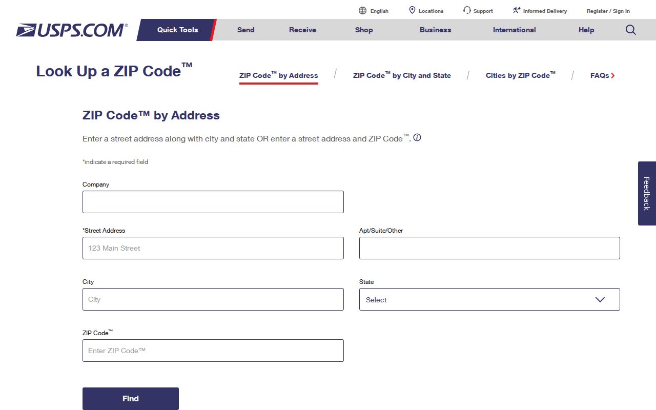
After the USPS result, keep the street, unit, postal city, state, ZIP, and ZIP+4 together; do not replace the legal parcel description with any of them.
North Carolina ZIP3 Regional Bands
ZIP3 ranges are broad orientation, not county maps or a substitute for a five-digit ZIP. North Carolina's 270-274 band points toward the northwestern Piedmont. The 275-279 band reaches across the Triangle, Sandhills, central and eastern parts of the state, including many rural and coastal routes. Prefixes 280-284 include the Charlotte area, south-central Piedmont, Fayetteville, and southeastern interior. The 285-289 group includes eastern and coastal communities as well as western mountain towns. A regional prefix cannot tell whether an address falls inside a particular municipality.
Postal data also treats service types differently. A five-digit ZIP can cover multiple routes; ZIP+4 narrows to a delivery segment. A PO-box-only ZIP may point to a postal facility, while a unique ZIP may serve one campus or institution. Census ZIP Code Tabulation Areas are useful for demographic summaries, but they are statistical approximations, not exact USPS delivery polygons. Keep the map purpose clear before comparing counts.
Find North Carolina Residents by ZIP Code
A ZIP search in North Carolina is not one statewide roster. County assessors may offer a ZIP field, but filters, address fields, and coverage differ by county. The state's parcel work standardizes fields across all 100 counties, including site and mailing address, owner, parcel identifier, deed reference, acreage, and sale date; the actual search screen remains local. NC OneMap can show statewide parcel geography and link toward county data, but the available address fields and refresh dates depend on the layer.
- Check the full address in USPS and save the five-digit ZIP, ZIP+4 if shown, and check date.
- Search the county assessor by situs address or parcel number first; use a ZIP filter only if that county's portal offers it.
- Compare site and mailing ZIPs separately, then use county GIS or NC OneMap to confirm parcel location and boundaries.
- Use the North Carolina voter lookup only for a named person. Its public profile search is not a ZIP-wide voter browser.
- If a lawful public voter-file request is needed, ask the county board or State Board for current rules, file date, fields, format, and any fee; no single statewide request form or fee was found.
- Once a ZIP is narrowed to a street, the North Carolina street directory workflow follows the parcel and street-level record trail.
A voter profile can show registration status, precinct, polling place, voting districts, sample ballot when available, absentee ballot information, and election history. It does not show ballot choices or protected fields. A ZIP search should therefore be treated as a way to narrow the address record, not as a way to list every resident in a postal area.
County ZIP Filters Across North Carolina
Use each tool for the question it can answer. A county tax system may return parcels whose stored mailing or situs ZIP matches the value entered. A GIS layer shows mapped parcels and address points. USPS checks the mail route, while a voter lookup checks one named profile. These results are related, but no one system makes a complete household list. North Carolina's parcel program gives counties a common data standard, not one statewide assessor search screen.
| Tool | What to use | What the result means |
|---|---|---|
| USPS lookup | Full delivery address | Postal ZIP assigned to that delivery point; not a parcel or household result |
| County assessor or tax portal | Situs address or PIN; ZIP only when the local search offers it | Tax parcel data with local field coverage; mailing and physical addresses may differ |
| NC OneMap and county GIS | Map, parcel, or address layer available for the area | Geography and linked parcel data; layer fields and update dates vary |
| NCSBE voter lookup | Required first and last name, optional year of birth and county | A named voter profile, not a ZIP-wide public roster |
The North Carolina parcels brief describes the common parcel fields, while the county assessor remains the custodian for its local tax layer. If the online search has no ZIP filter, ask the assessor or GIS office about its public counter, address lookup, or a specific data request. Check the parcel source and its field notes before reading a ZIP result as a list of people.
North Carolina Voter Profiles Are Name Based
The State Board of Elections' Voter Search asks for first and last name. Middle initial, year of birth, and county can narrow a match, and a user must select a voter status. The profile may show county, precinct, polling place, districts, sample ballot, absentee-ballot details when available, and past elections in which the person participated. This is a public lookup for a named voter, not a browser for all registered voters in a ZIP.
| Search field | Type | Required | Format or limit |
|---|---|---|---|
| Required First Name | Text | Yes | Exact or partial matching behavior is not stated |
| Middle Initial | Text | No | Optional |
| Required Last Name | Text | Yes | Required name field |
| Year of Birth | Dropdown or select | No | Optional narrowing field |
| County | Dropdown | No | Optional county filter |
| Voter Status | Checkbox group | At least one | Registered; Removed or Denied |
| Search | Button or control | Not applicable | Results load with JavaScript |
| Reset | Button or control | Not applicable | Clears the search |
The State Board's profile explanation says public lookup results do not include ballot selections. A full voter file is a separate release route. Research did not locate a current statewide request form, fee, delivery format, or commercial-use text, so the right channel is to ask the State Board or county board for current instructions instead of assuming a ZIP export is available. The State Board contact listed for corrections is P.O. Box 27255, Raleigh, NC 27611-7255, 919-814-0700; county board contact details vary. Historical voter-registration materials are being digitized by the State Archives, with coverage varying by item.
The Board's registration-statistics search supplies dated aggregate figures, not named voter profiles or resident counts by delivery ZIP.
Physical Addresses Behind ZIP Labels
Keep four location fields apart: postal city, incorporated municipality, county, and physical situs. A mailing ZIP can cross a municipal line or serve an unincorporated pocket. County, tax, school, fire, and utility districts can add still more boundaries. An assessor's mailing address is where a tax notice goes; the situs address is the physical parcel location, and the legal description is the recorded land identity. These are not interchangeable search terms.
North Carolina's local address systems add another layer. E911 and GIS offices assign or maintain road names and address points under county and local rules. Wilmington and New Hanover County use a directional grid based on the Cape Fear River and Market Street; other areas use different systems. If an older address fails, consult the local road-name or numbering record, parcel map, plat, or ordinance before concluding the property is absent. The Wilmington/New Hanover addressing manual is one local example, not a statewide model.
ZIP Codes and North Carolina City Limits
A ZIP line is a postal service boundary, not a city limit, county line, or legal property boundary. In North Carolina, an address may carry a nearby city's postal name while sitting in another municipality or in unincorporated county land. One city can have several ZIPs, and one ZIP can serve more than one town. A coastal ZIP may reach an unincorporated pocket or barrier-island route. Check the county and municipality in a parcel or boundary layer before choosing a local records office.
For a ZIP-wide demographic count, Census ZIP Code Tabulation Areas can give a useful summary geography. They are built for statistics and do not trace the exact USPS delivery routes. Census QuickFacts for North Carolina offers broader state and county context, but it does not turn a postal ZIP into a land or resident boundary. For a record about a single address, use USPS for mail delivery, the local parcel map for situs and county, and the deed's legal description for land identity. Keep the sources' labels as printed so the reason for a mismatch stays visible.
- ZIP vs ZIP+4
- A five-digit ZIP identifies a broad delivery area; the four extra digits narrow delivery to an address or segment and may change with routing.
- PO-box ZIP
- A ZIP assigned to box service at a post office. It may not map to residential land or a physical address.
- Unique ZIP
- A code assigned to a single large organization, institution, or campus rather than a broad residential area.
- Carrier route
- A group of delivery points served along a postal route. It is a delivery unit, not a public resident list.