
Finding a North Carolina Street Record Trail
North Carolina has no single statewide list of everyone at a street address. The useful public trail begins with the county that holds the parcel. A tax card can identify the legal owner, physical site, parcel number, and deed reference. A recorded deed can confirm a land transfer. Other records answer separate questions, and none should be treated as a complete list of people at the address.
Keep the full address as written, including direction, suffix, unit, postal city, ZIP, and county when known. North Carolina road names and address points are administered locally, so a clean match in one county system may require a different spelling or number in another.
- Search the county tax-assessor site by street address. Record the site address, owner name, mailing address, parcel identification number, deed reference, and map link when present.
- If the county is uncertain, use the statewide parcel map to find the parcel and its county. Zoom to the street and use the map identify tool to read each parcel card.
- Use the parcel number, book/page, or legal description to reach the relevant county Register of Deeds through the NC Association of Registers of Deeds county directory.
- For a named voter, search the North Carolina Voter Search. It is a person-by-name lookup, not a public list of everyone on a street.
- For an older address, ask the local library for a reverse or criss-cross directory. Check an occupant entry against its year and publisher before treating it as proof of residence.
This order keeps the current parcel and ownership trail at the center. Older directories can add useful address history, but the detailed household timeline belongs with the North Carolina Directory Book.
North Carolina Street Search Fields
County assessor tools across North Carolina differ, but the statewide parcel work has a useful common core. NC OneMap and the North Carolina parcels standard identify fields such as site and mailing address, owner, parcel ID, deed book and page, acreage, subdivision, use, and sale date. A local tax portal may add a building sketch, exemptions, sales history, or extra filters. Treat the exact field names and search options as county-specific.
| Search or Map Control | Type | Required | How to Use It |
|---|---|---|---|
| Site or property address | Text or autocomplete | No | Enter the house number, street, direction, and suffix; formatting varies. |
| Owner name | Text | No | Search the recorded legal owner; initials and name variants can matter. |
| Parcel ID or PIN | Text | No | Use this as the strongest bridge between map, tax card, and deed. |
| Mailing address | Text or result field | No | Keep it separate from the parcel's physical site address. |
| Subdivision, lot, or block | Text or dropdown | No | Options and labels depend on the county viewer. |
| Deed book and page | Paired fields | No | Where supported, follow the reference to the deed index. |
| Sale date or value | Date or number | No | May appear as a filter or only in the parcel history. |
| Identify, select, or layers | Map controls | No | Click parcels and turn on roads, zoning, flood, district, or boundary layers when available. |
The North Carolina parcels brief says all 100 counties participate in standardized parcel work and lists site and mailing addresses, owner, parcel ID, values, deed reference, acreage, subdivision, use, sale date, and refresh information. Local screens and tax-card detail still vary. A parcel result may include:
- Site address, tax-mailing address, owner name, and parcel identification number.
- Assessed land, building, and total value, plus structure count or structure-present flags.
- Deed book/page/date, acreage, subdivision, parcel use, and sale date.
- Transformed or refresh date; local-only additions may include a sketch, exemption detail, zoning, flood, or district layer.
The Wake County tax-search screen is one local parcel interface example, not a statewide assessor system.
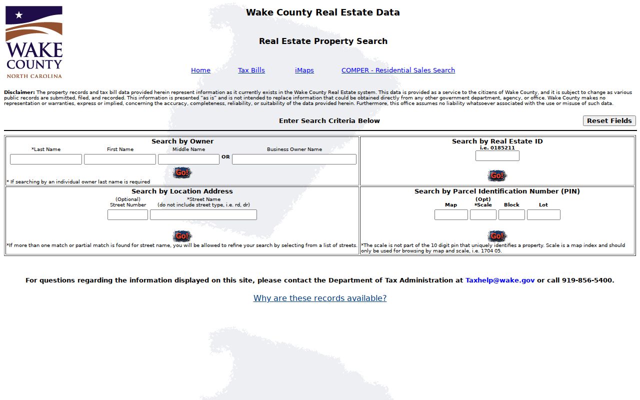
For another address, identify its county first and use that county's own tax and GIS links.
Browse North Carolina Streets in OneMap
NC OneMap provides statewide parcel geography and map layers. Search the road or a known address, zoom until parcel boundaries show, then click a parcel to inspect its available fields. Copy the parcel ID and any county source link before moving to another lot. The county GIS viewer remains the better source for its own tax-card details.
A map can help separate lots with similar street numbers or names, but its labels may be approximate. Compare a clicked parcel with the assessor card, recorded plat, and legal description. Layer choices vary and may include parcels, roads, aerial imagery, zoning, flood areas, districts, and municipal or county boundaries. Refresh timing and county-card links differ across North Carolina.
Follow a North Carolina Street Deed Link
Each North Carolina county Register of Deeds keeps its own land records. The statewide NCARD directory routes to local contact details and the county's own index, whose online start years, images, fees, and search options vary. Search the current owner as grantee or grantor, or use the parcel card's deed book/page or instrument number. A result may list the parties, document type, date, description, parcel reference, and image status. A grantor conveys an interest; a grantee receives it. A deed does not prove that the named person lived there.
A North Carolina deed index may also show:
- Grantor and grantee names, plus the role used to find the record.
- Instrument or document number, book/page, document type, and recording or execution date.
- Legal description, parcel number, prior instrument, and consideration or excise-tax field when supplied.
- Image access or status, copy rules, and any redaction or restriction notice.
A recorded plat links an address to a subdivision, lot, block, and map-book reference. For an older legal description without a street number, compare the lot with the parcel map. Deeds of trust, easements, assignments, and satisfactions describe other interests, not necessarily an owner change.
If an index or image is missing online, contact the county Register of Deeds by phone, mail, or public counter; older handwritten books may be on county or State Archives microfilm. The State Archives retention schedule explains public-record access, but no statewide online cutoff year exists. Original deed books usually remain local; the Archives holds indexes and microfilm for many counties, including records from almost all 100 current counties and six defunct counties. A missing web result does not prove the deed is lost.
North Carolina Records Searchable by Street
Address-linked records in North Carolina come from separate custodians. A parcel number ties the assessor map to land documents; a street address may guide a permit search; voter records need a person's name. None of these systems joins every occupant, owner, and past resident into one street roll.
| Record Set | Keeper | What It Shows | Access |
|---|---|---|---|
| Assessor and tax roll | County tax assessor | Owner, situs and mailing addresses, parcel ID, value, deed link, and local card details | County search, office counter, or a specific public-record request |
| GIS parcel map | NC OneMap and county GIS | Parcel boundaries, roads, address points, and available layers | Statewide viewer or local map; details and refresh vary |
| Deed, plat, and lien index | County Register of Deeds | Parties, document type, recording date, legal description, and image status | Local portal, phone, mail, or public counter; copy access varies |
| Permit and code file | City or county inspections/code office | Address, permit or case type, dates, status, applicant, and contractor when recorded | Local portal or office request; retention and filters vary |
| Named voter profile | North Carolina State Board of Elections | Status, county, precinct, districts, polling place, sample ballot, and election history | Free name search; voter-file requests have separate rules |
| Reverse directory | Local library or university | Past address-to-occupant or business entries for the volume's year | Catalog, local-history desk, licensed resource, or digitized scan |
The North Carolina Public Records Act, Chapter 132, provides a route to inspect or copy public records unless a specific law makes them confidential. A request for a defined parcel or address range may be useful when no download exists. Fees and timing vary by custodian, and the law does not set one statewide response deadline.
- Parcel
- A mapped tract of land assigned an identifier in the county tax or GIS system.
- Situs address
- The physical location of the parcel. A mailing address is where notices are sent and can be somewhere else.
- Plat
- A recorded map that lays out lots, blocks, roads, or easements in a subdivision.
- Criss-cross directory
- An address-first volume that may name an occupant or business for a specific city and year.
Read North Carolina Permits by Street Address
Permit and code files can show when a building was added, altered, inspected, or cited. Depending on the local system, an entry may include address, permit number, work type, issue date, status, applicant, owner, contractor, or inspection notes. That is a record of a project or agency action, not a resident list.
North Carolina has no single statewide permit search. Check the city or county inspections and code office that covers the parcel, then try its public portal, counter, phone, or written request route. Exact search fields and record retention are local. If the portal offers no address search, provide the parcel ID or a clear date range in a Chapter 132 request and ask which office holds the file.
Check North Carolina Voter Records by Name
The State Board of Elections Voter Search is the statewide named lookup. It can show a registration profile with status, county, precinct, polling place, districts, sample ballot information when available, absentee-ballot information when available, and voter history. It does not give a public browse of every registered person on a street, and ballot choices are not public.
| Voter Search Field | Type | Required | Research Note |
|---|---|---|---|
| First name | Text | Yes | Enter the person's first name; exact or partial matching is not specified. |
| Middle initial | Text | No | Optional. |
| Last name | Text | Yes | Enter the person's last name. |
| Year of birth | Dropdown | No | Optional narrowing field. |
| County | Dropdown | No | Optional county filter. |
| Voter status | Checkbox group | At least one | Choose Registered, Removed, or Denied status. |
| Search or Reset | Button | Search required | Results load in the page; Reset clears the form. |
A fuller North Carolina voter file is a separate channel. State law and confidential-field rules govern its release; the inspected state pages did not identify one current statewide fee or request form. Contact the county board or State Board for current requirements rather than assuming an address roster is available.
North Carolina Street Grids Vary by County
Address rules come from local road and emergency-address systems. County authority under Chapter 153A and local ordinances supports road naming or renaming and number assignment outside municipalities. Harnett County's E911/GIS application checks proposed road names, suffixes, duplicate names, and length. Alexander County describes GIS pre-addressing from street-centerline ranges, with some corner-lot numbers set before a driveway location is known.
Wilmington and New Hanover County offer a notable example: their addressing manual uses the Cape Fear River and Market Street as directional base lines. The Wilmington addressing standards are local rules, not a North Carolina-wide grid. For a past street number, ask the local GIS or planning office about road-name and number changes, ordinances, public notices, and address-point history.
The Harnett County road-name application and Alexander County road-naming ordinance show two different local approaches. Preserve the old and current address forms in your notes, then compare the parcel, plat, and map location rather than swapping one number for another.
A Pender County ordinance packet also cites county authority to name or rename roads and assign or reassign numbers. Treat these local rules as examples, then ask the county that holds the address for its own map or ordinance.
North Carolina Street Addresses Cross Local Labels
A postal city, incorporated municipality, county, tax district, and physical situs can all differ. A familiar postal name does not establish which government holds the land record. North Carolina parcels should be routed by the parcel's county, while the map can help compare city and county lines, district layers, and the street itself. Use the USPS address-to-ZIP lookup to check the delivery ZIP, then compare that postal label with GIS boundaries.
Keep situs and mailing addresses side by side. The situs is the physical property; the tax-mailing address is where notices go. A parcel can have an out-of-county mailing address, and a map label may not match the street name in a deed or older directory. Record both forms rather than overwriting one with the other.
For a resident list, this distinction matters because the parcel map speaks about land and the postal label speaks about delivery routing. Neither creates a verified list of people at a North Carolina street address.
What North Carolina Street Records Cannot Show
North Carolina public records do not form a household roster. A deed identifies a recorded land interest, a tax card gives parcel facts, and a voter profile is a named registration record. People who do not appear in those records cannot be added by inference, and a mailing address is not proof of current physical presence.
Some information is restricted. Federal Driver's Privacy Protection Act rules limit access to personal DMV data. Utility customer and private delivery records are not public address directories. North Carolina protected voter addresses, sealed court material, adoption files, health information, and confidential family records also have limits. Ask the relevant custodian about its lawful request process if a record is missing or a result needs correction.
Lawful use. Use North Carolina address records for lawful personal research, family history, or civic curiosity. Do not use them to stalk, harass, or intimidate anyone.